
Artificial Intelligence (AI) Approach to Generate and Analyze Transportation Planning & Design (TPD) Data at Scale
By: AIWaysion
Project Objective & Overview
During Phase I, AIWaysion successfully developed, demonstrated, and validated a scalable, AI-powered system to support transportation planning and design (TPD) by automating the generation, processing, and integration of multimodal infrastructure, safety, and contextual datasets.
The Phase I project's focus region was the City of Tucson, Arizona. The work was led by AIWaysion with technical collaboration from the University of Arizona's Center for Applied Transportation Sciences (CATS), and with support from the City of Tucson and guidance from FHWA program officials.
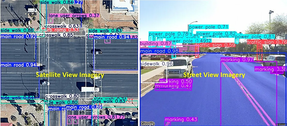
The project aimed to address critical data gaps, enhance data fidelity and accuracy, and streamline decision-support analytics by leveraging AI and computer vision (CV) to analyze street-view imagery, satellite imagery, roadside camera feeds, and other data sources.
Key Results & Findings
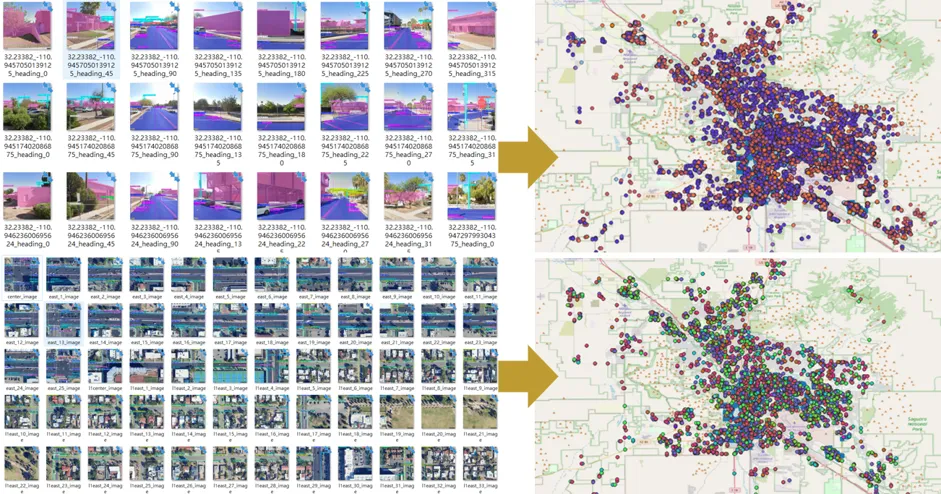
- TPD Data Collection Framework: Developed a robust, modular framework capable of aggregating GIS, satellite, street-view, and roadside camera/sensor feeds, enabling high-fidelity datasets.
- AI & CV Data Generation: Implemented advanced object detection and semantic segmentation models to extract roadway and infrastructure features such as sidewalks, crosswalks, bike lanes, signage, markings, control devices, surface conditions, etc.
- TPD Copilot with Vision-Language Model (VLM): Applied VLM models to translate geospatial and visual inputs into actionable planning insights. A user interface has been built for prompt-driven query input and output interpretation using VLMs.
Company Info
AIWaysion is a University of Washington spin-off specializing in AI-powered ITS solutions for state, local, and tribal DOTs. Our technologies support multimodal traffic data collection; detection of roadway, environmental, and visibility conditions; asset management; and detection of safety-critical events. AIWaysion also enables real-time safety interventions, including adaptive signal control and hazard condition alerts.
Project POC: wsun@aiwaysion.com
Website: www.aiwaysion.com
Next Steps
- Geographic Expansion: Extend data generation, validation, and tool functionality to more geographic areas including a range of urban, suburban, and rural development patterns and roadway contexts.
- Enhanced AI/CV Models: Improve object detection, segmentation, and predictive analytics models to increase accuracy across a wider range of infrastructure and behavioral features.
- Data Update and Automation: Develop workflows to support automated ingestion and seasonal updates of imagery, sensor feeds, and GIS data to meet evolving real-world conditions.
- Tool Development and User Interface: Advance the current prototype into a fully functional beta web-based tool, incorporating a streamlined interface that supports user-defined queries, scenario-based analysis, and visualization of both existing and proposed multimodal conditions.