
Complete Pavement Markings for Safe and Complete Streets

By: TrAnalytics LLC
Project Objective & Overview
This project develops a LiDAR-based framework to automatically detect pavement marking locations and assess their conditions, including retroreflectivity. Pavement markings play a vital role in communicating safety-critical information, such as yield and stop control, to road users. When they fade or deteriorate, they can compromise public safety and expose transportation agencies to legal liability.
To address this need, the project collected LiDAR data across approximately 210 miles of bike lanes in the Greater Boston area using vehicle-mounted, backpack/bike-mounted, and high-density airborne platforms. It also developed models for efficient point-cloud segmentation, pavement-marking extraction, and condition evaluation. All outputs were delivered in GIS-ready formats to support maintenance planning, asset management, and complete streets safety assessments.
Key Results & Findings
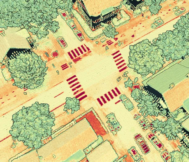
- Developed an automated LiDAR workflow for pavement marking detection, point-cloud segmentation, and retroreflectivity estimation.
- Utilized mobile, bike-mounted, and high-density airborne LiDAR to capture both fine-grained markings and corridor-wide features.
- Validated LiDAR-derived retroreflectivity against handheld measurements, confirming strong technical accuracy.
- NOAA LiDAR's low point density was insufficient for bike-lane markings. Mobile LiDAR provided the details needed for stencils and symbols but was sometimes hindered by traffic, parked vehicles, and access constraints.
- Identified high-density airborne LiDAR as a scalable solution for regional pavement-marking mapping.
- LiDAR platform selection requires a balance between resolution and coverage. A hybrid airborne–mobile approach may improve cost efficiency and data completeness in future deployments.
- The developed workflow can be expanded to extract additional complete-street assets.
Company Info
TrAnalytics is at the forefront of enhancing transportation safety through cutting-edge, data-driven solutions. By harnessing the power of advanced sensors and artificial intelligence, we tackle complex safety challenges on highways and on transit systems by employing proactive approaches.
Project POC: David Raucci
Email: draucci@tranalytics.us
Website: www.tranalytics.us
Next Steps
- Investigating additional high-density airborne LiDAR solutions such as Geiger-mode LiDAR.
- Expand the workflow for extracting additional complete-street assets, such as sidewalks, curb ramps, poles, lane widths, and signage, to broaden market applicability.
- Establish partnerships with state DOTs, MPOs, utility companies, and private LiDAR providers to integrate the technology into routine asset-management programs.
- Develop a cloud-based processing platform that agencies can use to upload LiDAR data and automatically generate GIS-ready pavement-marking datasets and condition assessments.